Report on Environmental Radiation Dose Rate Measurements in Fukushima area
by Ban Hideyuki, CNIC Co-Director
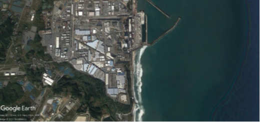
On May 11, 2011, the author set out to investigate radiation dose rates in the environment. At that time, we had chosen to conduct an investigation starting from the North Health Offices in Fukushima City and driving toward Iwaki City along routes 114, 288 and 399. Hoping to take measurements over as wide a range as possible, we chose to drive along these routes within a 20-km radius from the Fukushima nuclear power plants (Daiichi and Daini NPPs). We proceeded in the rain, taking measurements every three kilometers. We recorded the GPS data for use the following year. Along the way, however, we had gotten out of GPS range and had been unable to record the data.
The next year we attempted the same thing, taking measurements every three kilometers, but were unable to identify the same points as before, so we relied only on landmarks. In the third year, gates had been erected blocking access to the “areas where it is expected that residents will face difficulties in returning for a long time,” so we became unable to take measurements in the heavily contaminated Tsushima district. We took quite lengthy detours to continue our measurements. In 2018, Route 114 was fully reopened, but access to side roads was not allowed. On August 10 of this year, when four of us including Shizuri Kimiko of the Geological Disposal Research Group went out to take measurements, the major routes had all been reopened, so we were able to start taking measurements in the schoolyard of Tsushima Junior High School again for the first time in six years. In 2012, the dose there was 2.86 microsieverts per hour (μSv/h), but this year it had decreased to 0.35μSv/h. This was one of the places where decontamination waste had been stored. The flexible container bags were no longer there, and the schoolyard was overgrown with weeds. In the bushes to the side of the schoolyard, where decontamination looked unlikely to have been performed, the dose rate rose to as high as 1.5μSv/h. In Taikogi, Namie Town along Route 399, which we had likewise been unable to access, we had measured 4.92μSv/h in 2012, and that had fallen to 1.25μSv/h this year.
With shortcomings from the start, we were unable to obtain strict measurements, but we think what we were able to obtain will be useful in getting a rough idea of trends. The environmental radiation dose rate in Fukushima before the accident was 0.05 μSv/h or less, so comparatively high radiation levels persist. There were no signs of people in the houses along the investigated routes in 2011 and 2012, and no birds singing. There was nothing but an eerie silence. But as time has passed, the birds have returned and new houses can be seen as rebuilding proceeds. Little by little, signs of people are increasing.
On the second day we met
photographer Hida Shinshu, who led us to where he had found plants with
abnormalities. This was at the intersection of routes 49 and 114 in Hirusone,
Minamisoma City, where he had also led us to two years previously. Several fir
trees there were stunted in mid-growth, failing to continue growing upward.
Also, their needles had simply grown straight, not splitting into three, as
usual. Hida noted that he had never witnessed such abnormalities before. We
also saw a number of pine trees that had completely withered on the mountain
slopes by Route 114. Hida explained that this was different from the way pine
trees wither when attacked by pine bark beetles. These abnormalities may have
resulted from the effects of radiation. Large-scale investigations would
probably be needed to elucidate a causal relationship. However, we felt it
extremely important that people bring forth such examples so they can be compiled.